Below: South Orange on an 1895 map
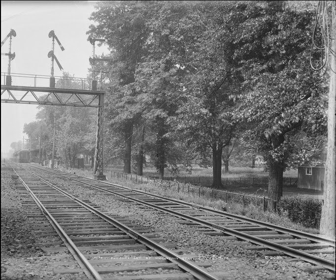
Above C1661: looking south (westward bound) along the RR across Montrose Avenue at the Mountain Station 9/5/1913
Below C1662: looking east along Montrose Avenue across RR, Mountain Station to right 9/5/1913
Above C1663: looking west along Montrose Avenue across RR, Mountain Station to left 9/5/1913
Below C1672: looking south (westward bound) along RR at Mead Street 9/15/1913
Below C1673: looking east along Randolph St across RR 9/15/1913
Below C1674: looking south (westward bound) along RR across Mead St 9/15/1913
Above C1675: looking east along Mead Street across RR 9/15/1913
Below C1676: looking west on Mead Street across RR 9/15/1913
Above C1677: looking south (westward bound) along RR across South Orange Avenue 9/15/1913
Below C1678: looking east on South Orange Avenue across RR 9/15/1913
Above C1679: looking west along South Orange Avenue across RR 9/15/1913
Below C1680: looking south along Railroad Alley beside westward bound RR, 1st Street intersection, as seen from the south end of the RR station 9/15/1913
Above C1681: looking south (westward bound) along RR across 3rd Street 9/15/1913
Below C1682: looking east along 3rd Street across RR 9/15/1913
Above C1683: looking west along 3rd Street across RR 9/15/1913
Below: 6/9/1914
Above C2084--South Orange, NJ--Montrose Avenue, eastward bound view down tracks (1914.06.09); Mountain Station is to photographer's right
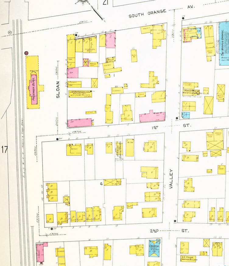
Below: The Mountain Station on a 1912 Sanborn Insurance map
Below C2085--South Orange, NJ--Mountain Station (1914.06.09); looking westward bound. Mountain Station platform in distant left
Below: detail from C2085 (above photo) showing Mountain Station platform at intersection with Montrose Ave , 6/9/1914
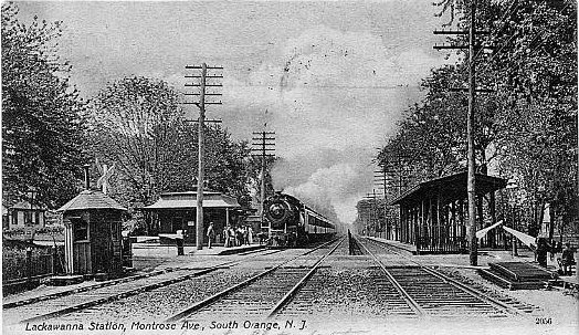
Above and below: postcard photos of Mountain Station looking westbound across Montrose Ave
C2086--South Orange, NJ--Montrose Avenue from Clark Street (1914.06.09)
C2087 South Orange, NJ--Meeker Street, eastward view (1914.06.09)
C2088--South Orange, NJ--Meeker Street, westward view (1914.06.09)
C2089--South Orange, NJ--Montrose Avenue, southward view from Meeker Street
(1914.06.09)
C2090--South Orange, NJ--Mountain Station (on right), eastbound side, Montrose Ave, green houses in background (1914.06.09)
C2091--South Orange, NJ--Montrose Avenue, westward view from Vose Avenue, greenhouses on left
(1914.06.09)
C2092--South Orange, NJ--Vose Avenue, Lowenthal Residence (1914.06.09)
C2093--South Orange, NJ--Vose Avenue, Michael Lyon Conservatory (1914.06.09)
C2094--South Orange, NJ--Randolph Place, northward view from Vose Avenue
(1914.06.09)
C2095--South Orange, NJ--Randolph Place, eastward view (1914.06.09)
C2096--South Orange, NJ--Mt. House Road, southward view from Meeker Street
(1914.06.09)
C2097--South Orange, NJ--West Turrel Avenue, southward view from Meeker
Street (1914.06.09)
C2098--South Orange, NJ--South Orange Field Club, looking SE toward railroad (1914.06.09)
Below: postcard photo looking SE toward railroad
C2099--South Orange, NJ--Grade crossing, Turrel Avenue, westward view
(1914.06.09)
C2100--South Orange, NJ--Grade crossing, Turrel Avenue, eastward view
(1914.06.09)
C2101--South Orange, NJ--Grade crossing, Mead Street, eastward view
(1914.06.09)
C2102--South Orange, NJ--ROW, westward view from playground (1914.06.09)
C2103--South Orange, NJ--ROW, eastward view from playground (1914.06.09
C2104--South Orange, NJ looking N across South Orange Ave on east side of tracks 13.9 (1914.06.09)
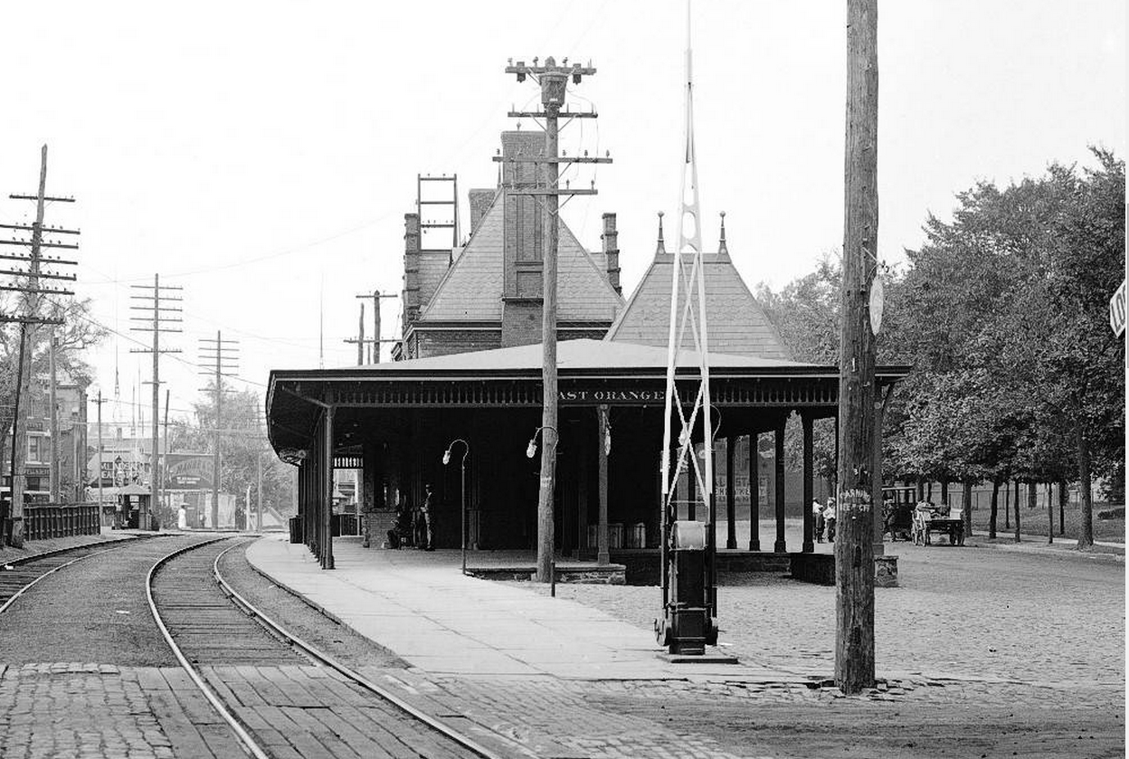
C2105--South Orange, NJ--looking S (westbound) across South Orange Ave at South Orange Station, South (1914.06.09)
C2106--South Orange, NJ- looking SW across South Orange Ave -Passenger station (1914.06.09)
Above and below: C2106--South Orange, NJ--Passenger station (1914.06.09)
Above and below: C2107 looking N toward South Orange Ave--South Orange, NJ--Passenger station (1914.06.09)
Above and below: postcard photos
C2108--South Orange, NJ--Railroad Alley between First and Second Streets (1914.06.09)
C2109--South Orange, NJ--Railroad Alley, Tennement House (1914.06.09)
C2110--South Orange, NJ--Railroad Alley, Rose Keirnan property, eastward
view (1914.06.09)
C2111--South Orange, NJ--Second Street, northward view (1914.06.09)
C2112--South Orange, NJ--H. B. Halsey Lumber & Coal Company (1914.06.09)
C2113--South Orange, NJ--H. B. Halsey Lumber & Coal Company, westward view
from Third Street (1914.06.09)
C2114--South Orange, NJ--Third Street, eastward view (1914.06.09)
C2115--South Orange, NJ--Freight House (1914.06.09)
C2116--South Orange, NJ--South Orange Avenue, Roll & Sickley Coal Yard (1914.06.09)
C2117--South Orange, NJ--South Orange Avenue, looking W across RR (1914.06.09)
C2118--South Orange, NJ--Freight House (1914.06.09)
C2119--South Orange, NJ--Third Street, Manda property (1914.06.09)
Above: C2120--South Orange, NJ--Grade crossing, Third Street, westward view (1914.06.09)
Below: C2121--South Orange, NJ--H. B. Halsey Lumber & Coal Company (1914.06.09
Above: C2122--South Orange, NJ--Fourth Street, northward view from Valley Street (1914.06.09)
Below: C2123--South Orange, NJ--H. B. Halsey Lumber &: Coal Company, eastward view (1914.06.09)
C2124--South Orange, NJ--ROW, westbound view with water tank (1914.06.09)
C2125--South Orange, NJ--Round house and interlocking tower (1914.06.09)
C2126--South Orange, NJ--Round house, interlocking tower and water tank,
eastward view (1914.06.09)
C2127--South Orange, NJ--Round house, interlocking tower and water tank,
eastbound view (1914.06.09)
Above: C2128--South Orange, NJ--ROW, 3 track main line, eastward view from Manda's
private crossing (1914.06.09)
Below: 10/1/1914
C2272--South Orange, NJ--ROW, westbound view with water tank, round house out of photo to the right (1914.10.01)
C2273--South Orange, NJ--ROW, view with water tank, round house to the far right (1914.10.01)
C2274--South Orange, NJ--ROW, eastward view with tower (1914.10.01)
C2275--South Orange, NJ--ROW, eastward view with tower (1914.10.01)

Below: 1912 Map showing area covered in 1917 photos below
Below: postcard photo postmarked 1907
Above C4096: 1917
Below C4097: Village Cemetery to the right 1917
Above C4098 and below C4099: Valley St Cemetery on east side of tracks near the intersection of Valley St and 5th St, 1917
Above C4100: 1917
Below C4101: 1917
Below C4102: 1917
Below: postcard photo of Montrose Lawn Tennis Club
Below: the station after elevation